Gunung Bekok, Johor: A Hiker's Guide (2026)
Gunung Bekok sits inside Taman Negara Endau–Rompin, Johor, and it doesn't mess around. At 953m, it's not the tallest peak in the state, but the elevation gain — somewhere between 1,191m and 1,200m depending on your GPS — tells you everything. This is a full-day grind through proper jungle: river crossings, leeches, steep scrambling, and a summit that rewards you with a cool, forested plateau rather than a sweeping panorama. One recent hiker put it plainly: don't come here chasing views. Come here for the jungle, the waterfall, the sense of earning something.

Bekok is lesser-known than Gunung Belumut or Gunung Ophir, which means fewer crowds and a wilder feel — but also less infrastructure and less tolerance for unpreparedness. You need a permit, you need a licensed guide, and you need to be honest with yourself about your fitness level. Hard terrain, multiple water crossings, and a long return trip means this hike suits experienced hikers who are comfortable on technical jungle trails. First-timers, this is not your warm-up hike.
That said, if you want a genuine Johor jungle experience — Hill and Upper Dipterocarp forest, rare flora like pokok redan, the sound of Sungai Bantang, and a summit that actually feels earned — Bekok delivers. Just go prepared.
Quick Facts
- Summit elevation: 953m
- Total elevation gain: 1,191–1,200m (3,635–3,906 ft)
- Distance: 10.6–14.3 km round trip (sources differ significantly — plan for the longer end)
- Estimated duration: 6–8 hours
- Difficulty: Hard / Moderately challenging (rate it Hard if it's been raining)
- Trailhead: Kampung Batu Empat, Taman Negara Endau–Rompin, Johor
- Permit required: Yes — from Jabatan Perhutanan Negeri Johor
- Guide required: Yes — mandatory, 1 guide per 7 hikers
- River crossings: 4–5
Getting There & Parking
The trailhead is at Kampung Batu Empat, within the Endau–Rompin park boundary in Johor. Getting here typically means driving — this is rural Johor, not somewhere you'll reach by public transport. Exact parking details at the trailhead aren't well-documented in available sources, so confirm parking arrangements with your guide or the forestry department when you sort out your permit. Your guide will also usually confirm meeting point logistics when you register.

Start early. A 6am departure at the trailhead is sensible for a 6–8 hour hike. You don't want to be doing river crossings or scrambling in fading light, and afternoon rain in Johor jungle is not something to gamble with.
Permits & Fees
A permit is mandatory and is obtained from Jabatan Perhutanan Negeri Johor (Johor State Forestry Department). You'll need a copy of your passport or MyKad for the application. Advance booking is strongly recommended — registration closes two weeks before your intended hike date, so don't leave this until the week before.
The exact permit fee isn't confirmed in any source we've seen, so don't rely on any figure you find floating around online — contact the forestry department directly for current pricing. Guide fees are also separate and should be agreed upon when you book your guide.
Trail conditions and permit requirements change — always check with the local forestry office or park authority before you go. Or ask the TAHAN Hiking Community on WhatsApp — someone's usually been there that week. Checking a different gunung? Try our free permit checker — instant answer for 90+ Malaysian mountains.
The Trail: What to Expect
The route runs one way in and the same way out. No loop option. Budget for the full 6–8 hours and treat that as a realistic estimate, not a challenge to beat.

Start: Kampung Batu Empat
The trail begins at Kampung Batu Empat. Initial terrain is jungle trail — expect roots, uneven ground, and humidity from the first step. This is Endau–Rompin, so the forest is thick and proper. The leech situation starts here and doesn't let up, so get your leech socks on before you move.
First River Crossing: Sungai Bantang & Waterfall
The first major landmark is the crossing of Sungai Bantang, where there's also a waterfall worth stopping at. The river crossing involves large boulders and rocks — take your time, test your footing, don't rush. This is where poles earn their keep. After heavy rain, water levels and current strength here can increase significantly.
Subsequent River Crossings (4–5 Total)
After Sungai Bantang, there are more crossings — sources report between 4 and 5 in total. Each one requires full attention. Wet rocks are slippery, and a rolled ankle or a fall into a boulder here is a long way from help. Cross one person at a time where the crossing is narrow or technical. Poles help enormously with balance.

Hentian Kolam Tengas (Last River Crossing Checkpoint)
Kolam Tengas marks the end of the river crossing section and is a natural rest point. Fill up on water here if your filtration system allows — reliable water sources above this point aren't confirmed, so treat this as your last guaranteed resupply. Rest your legs, refuel, and mentally prepare because the trail character changes significantly from here.
Steep Terrain After Kolam Tengas: Scrambling to the Summit
Above Kolam Tengas, the trail gets steep and technical. Hands-on scrambling is required in sections. The ground is muddy, roots are everywhere, and after rain this section becomes genuinely difficult. The trail has multiple rest shelters and benches — some sources count around 10 checkpoints along the full route — so you'll have places to stop and catch your breath. Use them.
There are two false peaks on the way up. You'll think you're nearly there. You're not. Don't let the false peaks crush your momentum — just keep moving at a steady pace.

Summit Plateau
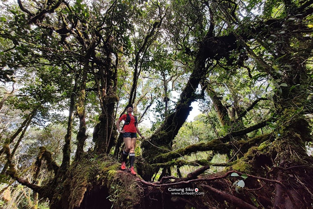
The summit of Gunung Bekok (953m) is a forested plateau — cooler and windier than the jungle below, which feels like a genuine reward after the climb. The forest here is Hill and Upper Dipterocarp ecosystem, with rare flora including pokok redan and diverse insect life. You won't get panoramic views through the canopy, but the microclimate and the forest character at the top are their own kind of payoff. Take your time here before heading down.
Descent & Safety
Coming down Bekok is not a formality. The steep, muddy sections above Kolam Tengas are arguably more dangerous on descent than ascent — gravity works against your footing on wet roots and mud. Slow down, especially on the scrambling sections, and use your poles for braking and balance.

The river crossings on the way back can be harder if afternoon rain has raised water levels. This is not hypothetical — it happens. Cross with the same care as on the way up.
Key hazards on this trail:
- River crossings: 4–5 crossings over large boulders; dangerous after rain
- Leeches: Abundant throughout. Leech socks are not optional on this trail.
- Slippery and muddy terrain: Worsens significantly during or after rain
- Steep scrambling above Kolam Tengas: Requires hands and full concentration
- Rocky technical terrain: Ankle injury risk is real
Turn back if: Weather deteriorates significantly, water levels at crossings look unsafe, anyone in your group is struggling badly before Kolam Tengas, or your guide advises it. A summit is optional. Getting everyone out safely is not.
Don't split your group, stay within earshot of your guide, and make sure someone not on the trail knows your plan and expected return time.
What to Bring
Pack for a full jungle day on hard terrain. This isn't a light trail — don't treat it like one.
- Water: Carry at least 2–3 litres. A hydration bladder like the TAHAN TrailBladder 2L keeps you drinking on the move without stopping to fish out a bottle — worth it on a full-day climb like this.
- Trekking poles: Honestly essential for the river crossings and the steep descent. The TAHAN 3-Section Foldable Hiking Stick V2 is light, packs small, and handles both jobs well.
- Leech socks: Non-negotiable. Pull them high.
- Grippy trail shoes or boots: Waterproof is a consideration but remember your feet will get wet at the crossings regardless. Grip matters more than waterproofing here.
- Rain jacket: Afternoon rain is a real risk. Pack it even if mornings look clear.
- Food and snacks: 6–8 hours of hard hiking burns serious energy. Pack real food, not just biscuits.
- First aid kit: Blister treatment, antiseptic for leech bites, any personal medications.
- Headlamp: If you're still on trail as light fades, you'll need it. Don't assume you'll be back before dark.
- Dry bag or waterproof liner: River crossings will test your pack's water resistance.
Check our hiking gear guide for more detail on what's worth spending on for Johor jungle trails.
FAQ
How hard is Gunung Bekok?
Hard. It's rated Hard on AllTrails and Moderately Challenging on other platforms — take the harder rating seriously. Over 1,190m of elevation gain, multiple river crossings, steep scrambling, leeches, and 6–8 hours of jungle terrain. This is not a beginner hike. If your longest hike to date is Broga or Bukit Tabur, build up more experience first.
How long does Gunung Bekok take?
Most hikers report 6–8 hours for the full round trip. Plan for the longer end if you're not a fast hiker, if conditions are wet, or if you have a larger group. An early start — around 6am — is strongly recommended.
Do I need a permit for Gunung Bekok?
Yes, a permit is mandatory from Jabatan Perhutanan Negeri Johor. You also need a licensed guide — the requirement is 1 guide per 7 hikers. You cannot do this trail independently. Advance registration closes 2 weeks before your hike date, so plan accordingly.
Is there water on the trail?
There's water at Sungai Bantang and at the river crossing points in the lower sections of the trail. Whether there are reliable water sources above Hentian Kolam Tengas isn't confirmed — treat Kolam Tengas as your last guaranteed water point and carry enough from there to the summit and back.
Camp Nearby?
Making a weekend of it? There are some decent options in the Johor region worth looking at. Jungle X Camp, Gunung Pulai keeps you in the jungle spirit if you want to extend the trip. For something more comfortable before or after a big hike, HRF Glamping House, Senggarang Johor is worth considering. And Otternest Camp, Pulai is another Johor option if you want a proper base. Staying close the night before means you can hit the trailhead early without a brutal pre-dawn drive from KL.
Trail conditions, permit updates, and hiking buddies for the weekend — all in one WhatsApp group. Just ask; someone was probably up there last week.
💬 Join the Hiking CommunityFree, one click. No spam — the occasional promo at most.
Gear tip: Water bladder or bottle on a humid trail.
Mike has been camping across Malaysia for over 10 years — from jungle treks in Taman Negara to beach camps in Perhentian. He writes about it so you don't have to find out the hard way. Follow along on TAHAN Outdoor's blog for honest campsite reviews, every week.
⛺ Featured in: Air Terjun Johor: 5 Waterfalls Worth the Drive (2026)