Gunung Datuk, Negeri Sembilan: A Hiker's Guide (2026)
Gunung Datuk punches above its height. At 884 m, it's not the tallest hill in Negeri Sembilan — but the combination of steep jungle terrain, an iconic boulder scramble at the top, and a genuinely sweeping 360-degree view that stretches all the way to Selat Melaka makes this one of the most rewarding half-day hikes in the south. People drive up from KL and across from Melaka specifically for this summit, and you'll understand why the moment you climb those final steel ladders.

Who is this hike for? Moderately fit adults who are comfortable with steep, rooty jungle trails and don't mind using their hands on the final boulder section. It's short enough that beginners who pace themselves can manage it — but make no mistake, the lower trail is relentlessly steep and will humble people who underestimate it. Experienced hikers use it as a Kinabalu training hike. That tells you something about the gradient.
The trail sits inside Hutan Lipur Gunung Datuk in Rembau District — a proper managed recreational forest with an entrance booth, registration system, and operating hours. It's accessible, it's popular on weekends, and it rewards an early start. Here's what you need to know before you go.
Quick Facts
- Summit elevation: 884 m (2,900 ft)
- Elevation gain: ~580–585 m
- Distance: ~4 km return (~2 km one-way)
- Time: Ascent 1–2 hours (fit hikers ~45 min); full return at moderate pace 3–3.5 hours; up to 5–6 hours with extended summit time
- Difficulty: Moderately hard (some sources rate Hard — respect that)
- Entrance fee: RM 5 per person (Malaysians); RM 20 per person (international visitors — single source, verify before going)
- Permit / registration: Yes — mandatory name registration at entrance booth before and after hiking
- Operating hours: 08:00–17:00 daily (one hiker reports entry cut-off around 12:30 pm — check on arrival)
- Guide required: Not compulsory for Malaysians; from October 2026 onwards, international visitors may be required to hire a licensed guide — verify with the park before going
- Location: Rembau District, Negeri Sembilan — ~100 km from KL, ~50 km from Melaka
Getting There & Parking
By car, take the North-South Expressway and exit at Exit 223 (Pedas/Rembau). Follow signs for Hutan Lipur Gunung Datuk along route N111 — the road takes you through rubber estate before reaching the base camp. GPS coordinates: 2.543582, 102.169123. From Rembau town it's about 12.7 km.
The car park at the trailhead is small. On weekends and public holidays it fills up fast — overflow means roadside parking along the approach. Arrive early. Seriously, aim for right at 8:00 am opening, or even earlier if you've arranged online payment and the gate allows earlier entry. A parking fee of RM 2 per entry has been reported, though this comes from a single source — have small change ready just in case.
No direct public transport goes to the trailhead. If you're coming without a car, the most practical option is KTM to Seremban, then a bus from Terminal 1 to Rembau and alight at Kota — from there it's about a 2.5 km walk to the trailhead. Alternatively, KTM to Tampin then a taxi or Grab to the base. Factor this in — the last stretch has no rideshare drop-off point at the trail itself, so sort your logistics the night before.
Permits & Fees
Registration is mandatory — you sign in at the entrance booth before you hike and sign out when you return. This isn't just bureaucracy; missing hiker incidents have happened here historically, and that registration is how the forestry staff know who's still on the hill at closing time.
Entrance fee is RM 5 per person for Malaysian hikers, confirmed by multiple sources. International visitors have been charged RM 20 — this figure comes from a single source and may not reflect the official rate, so verify directly. From October 2026 onwards, there are reports that foreign visitors will be required to use a licensed guide — if you're bringing international friends, contact the park authority to confirm current requirements before the trip.
Camping is permitted: RM 3 per person per night, with 4-man tents available to hire for RM 5 per tent (single source — confirm on-site). Payment can reportedly be made online via the N9PAY platform. Optional guided hike fees: under 20 pax RM 60, 25–50 pax RM 120, over 50 pax RM 180 (single source).
The issuing authority is Jabatan Perhutanan Negeri Sembilan. Their office is at Pejabat Hutan Daerah, Negeri Sembilan Barat, Level 2, Kompleks Pentadbiran Daerah Seremban. Phone: 06-601 4000.
Trail conditions and permit requirements change — always check with the local forestry office or park authority before you go. Checking a different gunung? Try our free permit checker — instant answer for 90+ Malaysian mountains. Or ask the TAHAN Hiking Community on WhatsApp — someone's usually been there that week.
The Trail: What to Expect
The route is well-marked throughout with frequent trail markers. That said, there's one navigation trap early on that has caught people out — more on that below. The trail is a there-and-back route; you ascend and descend the same path.

Stage 1 – Trailhead & Registration Booth
You'll spot the rainbow-coloured stairways right at the trail start — hard to miss, and they make for a fun photo before the suffering begins. Register your name at the booth here, pay your fees, and use the toilet facilities before heading in. There are no facilities further up the trail.
Stage 2 – Stream Crossing
Shortly after the stairway, the trail dips downhill to a stream near the park HQ. You'll cross via a bridge or small dam walkway — no wet feet required in normal conditions. Pay attention here: the correct trail continues on the earth path to the RIGHT. The concrete path going left is the wrong way. This is a documented navigation error point — one that's easy to make if you're chatting and not watching for it.
The stream at the base is confirmed as a water source — fill up here if needed, because there are no confirmed water points along the trail above this.
Stage 3 – Lower Forest: The Steep Bit

This is where the hike earns its reputation. The first roughly 50 minutes of trail is the steepest and hardest section of the entire route. Dense tropical rainforest, wooden steps, knotted ropes, large exposed roots and boulders — you'll be using your hands regularly. The massive buttress-rooted trees here are genuinely impressive if you can spare the breath to look at them.
Don't rush this section. Pace yourself. If you're breathing hard and your legs are burning 10 minutes in, slow down — there's plenty more trail ahead. Leeches are active here, especially after rain. Leech socks and gloves are strongly advised. Wear them before you enter the forest, not after you feel something on your ankle.
Stage 4 – Mid-Section & Checkpoint
Terrain eases slightly as you gain the mid-section. Trail markers continue to guide the route. This is a good place to take a short break, drink water, and check how everyone in your group is doing. The gradient is still significant — "slightly less steep" is relative on Gunung Datuk — but you'll feel the worst of the climbing is behind you.

Stage 5 – Upper Approach & Summit Boulders
As you near the summit, the canopy breaks and the views start opening up on the exposed boulders. The signature final obstacle is a two-storey-high boulder with steel ladders installed — this is the climb that ends up in everyone's photos, and rightfully so. Take it one person at a time, maintain three points of contact, and don't rush the person ahead of you.
Summit – 884 m

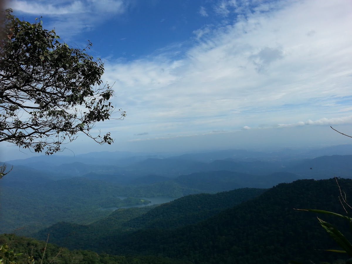
Unshaded, open rock with a full 360-degree panoramic view. On a clear morning you can see Selat Melaka to the west. It's genuinely one of the better summit payoffs for a trail this short in Peninsular Malaysia. Be aware: the summit is fully exposed with no shade. UV up here is serious — apply sunblock before the climb, not when you're already up top. Wind can pick up too, so a light layer is worth having in your pack.
One recent hiker noted a lot of bees on their May 2026 visit — not typically a hazard but worth knowing. Don't swat, don't panic, give them space.
Optional Extensions
From the summit, the Trans YamTuan Antah Trail continues to Gunung Gagak (about 45 minutes further) and then Gunung Rembau (roughly another 10 minutes). A more serious full-day option is the Trans Naning Trail, a ridge traverse that connects up to 7 peaks along the southern Titiwangsa range including Gunung/Bukit Tampin. These extensions are described by a small number of sources — if you're planning either, get current conditions and route information from experienced locals or the forestry office before committing.
Descent & Safety

What goes up steeply comes down steeply. The descent on Gunung Datuk is where knees take punishment — the same roots and boulders you hauled yourself up now need to be lowered down carefully. Loose pebbles on the trail become a slip hazard on the way down, especially if the ground is wet or your legs are tired.
Take your time. More twisted ankles happen on descents than ascents. If you have any knee concerns, a hiking pole makes a real difference on this trail — the TAHAN 3-Section Foldable Hiking Stick V2 collapses compact enough to stow when you need both hands on the boulder sections. Same story for knee support — if your knees are your weak point, the TAHAN Kinetix Knee Guard With Spring Support is worth having on before you start the descent, not after your knee starts complaining halfway down.
Key hazards summary:
- Steep terrain throughout — especially the lower trail on both ascent and descent
- Slippery and muddy conditions after heavy rain — if it's been raining, consider postponing
- Loose pebbles on descent — slow down, watch your footing
- Leeches — wear leech socks and gloves in the forest sections
- Exposed unshaded summit — high UV and wind; sunblock and a light layer are not optional
- Navigation error point at stream near start — stay right on the earth trail
- No water on the trail above the base stream — carry everything you need from the bottom
Turn back in bad weather. This trail is not safe in heavy rain. Wet roots and steep terrain is a dangerous combination. The park closes at 17:00 — if you're not confident you can descend before then, don't push for the summit. Carry a headlamp regardless; the forest gets dark fast if anything delays you.
Solo hiking by hikers unfamiliar with the trail is not recommended. Go with at least one other person, and make sure someone not on the trail knows your plan and expected return time.
What to Bring
This is a short hike but a physically demanding one with a hot, exposed summit. Pack accordingly:
- Water: Minimum 1.5–2 litres per person. No water sources on trail above the base stream. A hydration bladder keeps your hands free on the steep sections.
- Hiking shoes: Proper grip is non-negotiable on the roots and boulders. Trail runners at minimum; hiking boots preferred in wet conditions.
- Leech socks: Not optional in Malaysian jungle. Put them on before you enter the trail.
- Gloves: Useful for the rooty lower section and the final boulder climb — also double as leech protection.
- Sunblock + hat: The summit is fully exposed with zero shade. High UV.
- Light rain jacket or poncho: Weather in the hills changes fast. An unexpected downpour makes the descent significantly more dangerous.
- Headlamp: Even for a day hike. If something delays you, the forest gets dark quickly.
- Whistle: Small, light, and required kit.
- Snacks and lunch: No stalls or facilities on the trail. Eat before you go and bring energy food for the summit.
- Hiking pole: Especially valuable on the descent for knee protection. See our hiking gear guide if you're trying to decide what to bring.
- Small first aid kit: Plasters, antiseptic, and blister care at minimum.
FAQ
How hard is Gunung Datuk?
Moderately hard. AllTrails rates it Hard; other hikers rate it Moderate. The honest answer: the lower trail is steep and relentless, you'll be using your hands on roots and ropes, and the final boulder requires a ladder climb. Fit adults who hike regularly can manage it comfortably. If you're newer to hiking, go slow, go early, and don't underestimate it. It's commonly used as a Kinabalu training hike — that's a useful benchmark.
How long does the Gunung Datuk hike take?
Most hikers take 1–2 hours on the ascent (very fit hikers can do it in around 45 minutes). A comfortable return at moderate pace including a summit break is around 3–3.5 hours total. If you spend more time at the top or your group moves slowly on the steep sections, plan for up to 5–6 hours. Given the park closes at 17:00 and entry may be cut off around 12:30 pm based on hiker reports, an early morning start is strongly advised.
Do I need a permit for Gunung Datuk?
There's no separate hiking permit, but entrance fees and mandatory name registration at the booth are required. Malaysians pay RM 5 per person. International visitors have been charged RM 20 (single source — verify before going). From October 2026 onwards, international visitors may also be required to hire a licensed guide — check with Jabatan Perhutanan Negeri Sembilan (Tel: 06-601 4000) before your trip if this applies to you.
Can beginners hike Gunung Datuk?
Beginners who are reasonably fit and willing to take it slow can complete this hike. The trail is well-marked, it's a manageable distance, and the steep sections have ropes and wooden steps to assist. That said — it's not a casual nature walk. Come with proper footwear, sufficient water, leech socks, and realistic expectations about the gradient. Going with an experienced hiking friend for your first time here is the sensible move.
Camp Nearby?
Making a weekend of it? Negeri Sembilan has some solid camping options within reasonable range of the trailhead. Last Post D'Rimba Campsite, Negeri Sembilan is worth a look if you want to stay within the state. For something a bit different, De Star Glamping, Lenggeng is a comfortable option if you'd rather not rough it the night before a steep morning climb. And if you're open to ranging a bit further into the interior, Berhulucamp, Jempol is a good base for a longer Negeri Sembilan hiking weekend. Staying nearby the night before means you can hit the trailhead right at 8:00 am — which genuinely makes a difference for parking and beating the weekend crowds.
Trail conditions, permit updates, and hiking buddies for the weekend — all in one WhatsApp group. Just ask; someone was probably up there last week.
💬 Join the Hiking CommunityFree, one click. No spam — the occasional promo at most.
Gear tip: How to use a trekking pole (and set the height).
Mike has been camping across Malaysia for over 10 years — from jungle treks in Taman Negara to beach camps in Perhentian. He writes about it so you don't have to find out the hard way. Follow along on TAHAN Outdoor's blog for honest campsite reviews, every week.