Bukit Wawasan, Puchong: A Hiker's Guide (2026)
Bukit Wawasan sits inside Ayer Hitam Forest Reserve — one of the last surviving patches of primary lowland dipterocarp forest in one of the most urbanised corridors in Selangor. You're doing this hike surrounded by Puchong housing estates and LDP traffic, yet once you step under that canopy, it genuinely feels like jungle. That contrast is the whole point.

The standard permitted loop (Trail A and Trail B) is roughly 5 km and suits beginners who are reasonably fit, families with older kids, and anyone wanting a quick nature fix without driving two hours out of KL. That said, don't let the numbers fool you — after rain, this trail turns slippery and rooty enough to humble experienced hikers. Easy-to-moderate is the honest call, and the conditions on any given day are what really set the difficulty.
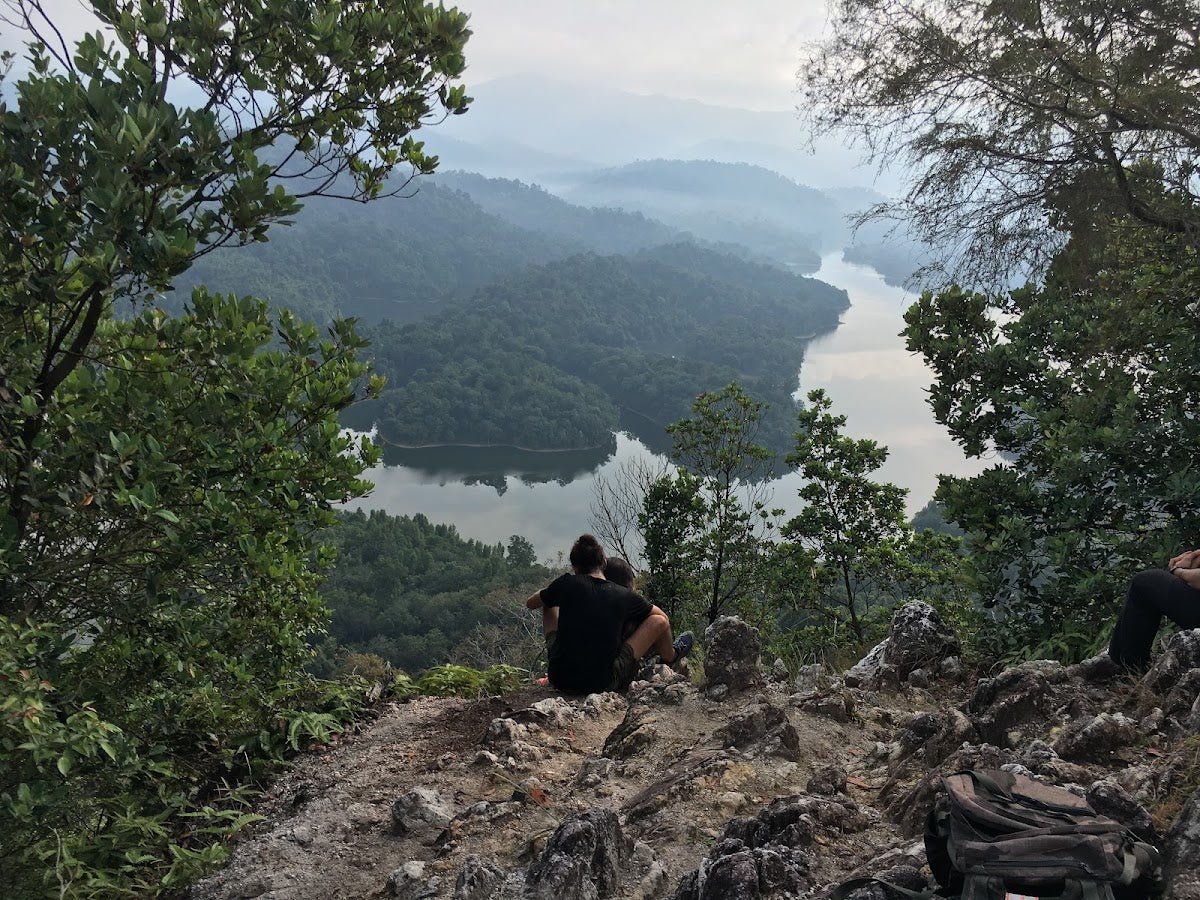
A note before we go further: most of Ayer Hitam Forest Reserve is restricted. Only Trail A and Trail B are open to casual hikers. There are branching paths that lead into off-limits zones — including the famous Blue Lake — and trespassing carries a fine of up to RM10,000 or 3 years imprisonment, or both. Stay on the marked trails. It's not worth it.
Quick Facts
- Summit elevation: 233 m / 764 ft ASL
- Standard permitted loop (Trail A/B): ~5 km
- Short inner loop: ~2–2.25 km
- Waterfall trail variant: ~4 km
- Extended outer loop (restricted — do not enter): 7.4 km
- Duration (standard 5 km loop): 1 hour 20 min – 2 hours depending on pace
- Duration (short inner loop): ~1 hour
- Difficulty: Easy to moderate; slippery and harder after rain
- Permit required: No, for Trail A and Trail B — free access
- Guide required: No
- Opening hours: 8:00 AM – 4:30 PM
- Entrance fee: Free
- Parking fee: Free
Getting There & Parking
The main trailhead is at Persiaran Bukit, Taman Wawasan, 47100 Puchong, Selangor. Search "Wawasan Hill entrance" or "Wawasan Hill Trail (Entrance)" on Waze or Google Maps and it'll get you there. From Petaling Jaya, you're looking at roughly 10 km and about 20 minutes on a good day — less if you leave before the morning rush.
There's also a second entrance near Jalan Wawasan 4/12 and another near the MBSJ recycle centre. The waterfall trail starts from a different point entirely — Jalan BK 5B/1 — so if that's your plan, plug that in separately.
Parking is free and there's an open area near the trailhead. On weekends, especially weekend mornings, it fills fast. Don't be surprised if you end up parking a few hundred metres down the road and walking to the entrance. No big deal, but plan for it. One thing to flag: there's no toilet at the trailhead. Nearest one is reportedly a 5-minute drive away — sort yourself out before you arrive.

Permits & Fees
Trail A and Trail B are free to enter — no permit, no registration, no entrance fee. Just show up during opening hours (8:00 AM – 4:30 PM).
The forest is private property under a lease arrangement between UPM (Universiti Putra Malaysia) and the Selangor state government, and the permit authority sits with Jabatan Perhutanan (the Forestry Department) and UPM. If you want to do research visits or access restricted areas legitimately, contact UPM via forenv.upm.edu.my.
The Blue Lake / Blue Lagoon — yes, the one all over Instagram — requires a separate permit from the landowner. Most sources strongly advise against attempting to access it without that permit. The on-site signage is clear: trespassing into restricted zones is an offence carrying a fine of up to RM10,000, 3 years imprisonment, or both. Don't risk it.
Trail conditions and permit requirements change — always check with the local forestry office or park authority before you go. Checking a different gunung? Try our free permit checker — instant answer for 90+ Malaysian mountains. Or ask the TAHAN Hiking Community on WhatsApp — someone's usually been there that week.
The Trail: What to Expect
The standard permitted loop takes you through genuine lowland rainforest — think exposed roots underfoot, dappled canopy, occasional wildlife, and a proper jungle feel despite being minutes from Puchong. Here's the route stage by stage.
Trailhead at Persiaran Bukit
The trail starts roadside at Persiaran Bukit. There may be food stalls near the entrance — but reports of this are from 2019 and current status is unverified, so eat before you come. Step in, and the city noise drops almost immediately. The canopy closes overhead pretty quickly.

Datuk Gong Chinese Shrine
Not far from the start, you'll pass a Datuk Gong Chinese shrine. It's a genuine cultural landmark — well-maintained, and a good marker that you're on the right path. Some loop variants bring you back past it on the return too.
Forest Ascent — Undulating Terrain
This is the bulk of the hike. The trail is unpaved throughout, with exposed tree roots being the main constant. The terrain undulates — you're not grinding uphill the whole way, but there's enough up-and-down to keep your legs working. There are occasional lookout points through the trees. Hikers consistently mention that mosquitoes can be thick in patches through here, so bring repellent. Wildlife sightings — monkeys, chameleons, wild mushrooms — are part of the experience if you're moving quietly.

Final ~200 m to Summit
The last roughly 200 metres to the top are noticeably steeper than the rest of the trail. This is where poles earn their keep — the roots and slope combined with any moisture on the trail make this section properly demanding. Take your time here, especially on the way up. It's short but it bites.
Summit / 'TOP OF THE WORLD' Viewpoint
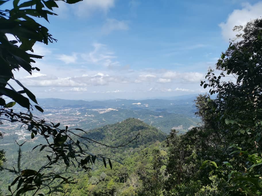
At 233 m, the summit has a viewpoint — literally signed "TOP OF THE WORLD" — with panoramic views over Puchong township and the surrounding forest canopy. It's a satisfying payoff, and a stark reminder of how much concrete surrounds this little green pocket. Good spot to catch your breath and take photos before heading down.

Descent Including Stream Crossing
The descent route includes a stream crossing. After rain, this can be slippery on both banks — watch your footing. The trail continues through forest back toward the trailhead, passing the creek and pond area.
Creek/Pond Area — Tortoises
Near the trail end, there's a small creek and pond where you can often spot tortoises. Multiple hikers have flagged this as a highlight — it's one of those unexpected lowland forest moments that makes Bukit Wawasan feel like more than just a suburban hill. Worth slowing down here.
Return to Trailhead
Depending on which loop variant you took, you may pass the Datuk Gong Shrine again before popping back out at Persiaran Bukit. Total loop is roughly 5 km; most people finish between 1 hour 20 minutes and 2 hours. You could also connect onward to Kinrara from here if you want to extend the day — but that's a separate plan requiring its own preparation.

Descent & Safety
The descent is where most incidents happen on hikes like this — and Bukit Wawasan's main hazards are all gravity-and-surface related. Know what you're dealing with:
- Mud and slippery terrain — the most consistently reported hazard across all sources. After any significant rain, this trail becomes genuinely difficult. If it's been raining, reconsider or go very slowly.
- Exposed tree roots — everywhere. Ankle-roll territory if you're not watching your feet.
- Stream crossing on descent — wet rocks, slippery banks. Don't rush it.
- Steep final ~200 m — both up and down. More demanding than the rest of the trail.
- Unmarked branching trails — multiple paths lead off into restricted areas. Stick to Trail A and Trail B. If a path looks unofficial or unmarked, it probably goes somewhere you shouldn't be.
- Monkeys near the entrance — described as aggressive by at least one source. Don't feed them, don't make eye contact unnecessarily, and keep bags closed.
- Trespassing risk — fines up to RM10,000 or 3 years imprisonment. Not worth any shortcut or Instagram spot.
Opening hours close at 4:30 PM — factor in your start time. This is a short hike, but getting caught out in lowland jungle after dark is still not fun. If weather turns bad mid-hike — heavy rain, thunder — turn around. The roots and slopes on this trail become seriously dangerous when wet.
What to Bring
- Water — there are no potable water sources or refill stations on trail. Bring enough for your whole hike. For a 5 km loop in Selangor heat, minimum 1.5–2 litres per person. A hydration bladder like the TAHAN TrailBladder 2L keeps things hands-free and makes it easier to drink consistently without stopping.
- Footwear — proper trail shoes or hiking boots with grip. Sandals or running flats are asking for trouble on rooty, muddy terrain.
- Hiking poles — optional but genuinely useful on the steep final section and the descent, especially after rain. The TAHAN 3-Section Foldable Hiking Stick V2 packs away when you don't need it and deploys fast when you do — good fit for a shorter hike like this where you don't want to carry a full-size pole the whole loop.
- Mosquito repellent — not optional. Multiple hikers flag this. Bring it and use it from the start.
- Light snacks — it's a short hike, but eat something before you go. Don't rely on stalls at the entrance being open.
- Rain jacket or dry bag — Selangor afternoon storms can appear fast. A light packable jacket takes no space.
- Charged phone with offline maps — the branching trail situation makes navigation genuinely important here. Download your map offline before you leave.
- Extra grip or change of socks — if you're coming from a long day or doing a longer loop, clean dry socks mid-hike are underrated.
For a broader look at what gear is worth carrying on Malaysian hikes, check out our hiking gear guide — covers poles, knee guards, and what's actually useful versus what just takes up space in your pack.
FAQ
How hard is Bukit Wawasan?
Easy to moderate on a dry day. Beginners and families with older kids can manage the standard 5 km loop comfortably. The trail becomes significantly harder after rain — muddy, slippery, and the rooty terrain becomes a proper hazard. The steep final 200 m to the summit is the toughest single section. If you're a beginner and it's been raining recently, start with the shorter inner loop (~2.25 km, ~1 hour) and see how you feel.
How long does Bukit Wawasan take?
The standard permitted loop (~5 km) takes most hikers between 1 hour 20 minutes and 2 hours. The short inner loop is about 1 hour. If you're doing the waterfall trail variant (~4 km), allow similar time. Leave a buffer — don't be cutting it close to the 4:30 PM closing time.
Do I need a permit to hike Bukit Wawasan?
No permit or entrance fee for Trail A and Trail B — just show up between 8:00 AM and 4:30 PM. The Blue Lake requires a separate landowner permit and is off-limits without it. Research visits or access to restricted areas requires going through UPM and Jabatan Perhutanan. Step-by-step application guide: how to apply on SeForest.
Is the Blue Lake / Blue Lagoon accessible?
Not without a separate permit from the landowner, and most sources strongly advise against attempting it without one. On-site signage states fines of up to RM10,000 or 3 years imprisonment for trespassing into restricted areas. Leave it out of your plans unless you have the proper permission sorted in advance.
Camp Nearby?
Bukit Wawasan is a half-day hike at most — not an overnight trail — but if you want to make a proper outdoor weekend of it and base yourself somewhere green, there are a few solid options within range. Making a weekend of it? Mori Leka Campsite, Serendah is a popular pick in Selangor for a lush, laid-back camp night. Further out but worth the drive, Nature Escape Campsite, Hulu Langat puts you deep in the valley greenery. Or if you want something a bit more structured with jungle atmosphere closer to KL, Templer Park Rainforest Retreat is a well-known option that pairs well with a morning hike before the heat sets in.
Trail conditions, permit updates, and hiking buddies for the weekend — all in one WhatsApp group. Just ask; someone was probably up there last week.
💬 Join the Hiking CommunityFree, one click. No spam — the occasional promo at most.
Gear tip: How to use a trekking pole (and set the height).
Mike has been camping across Malaysia for over 10 years — from jungle treks in Taman Negara to beach camps in Perhentian. He writes about it so you don't have to find out the hard way. Follow along on TAHAN Outdoor's blog for honest campsite reviews, every week.
⛺ Featured in: 10 Easy Hikes Near KL for First-Timers (2026)
⛺ Featured in: The 10 Best Hikes in Selangor (2026)