Gunung Senyum: A Hiker's Guide (2026)
Gunung Senyum is one of Pahang's best-kept secrets — a limestone karst massif rising to around 478 m above the Jengka Forest Reserve, studded with 19 to 25-plus caves and capped by a summit that rewards with sweeping views over virgin lowland rainforest, the Pahang River, and Krau Wildlife Reserve. It sits about 40 km from Temerloh, roughly two hours from KL, and yet on a weekend trip in May 2025 one group reported meeting only two other parties on trail. That tells you something about how crowd-free this place still is.

Don't let the modest elevation fool you. Gunung Senyum is rated Hard on AllTrails for good reason — one source describes it bluntly as "80% rock climbing, 20% hiking." The upper trail involves exposed boulder scrambling with no trail markers above the third checkpoint. If heights make you nervous, or if the rocks are wet, this hike becomes genuinely dangerous. It suits physically fit hikers who are comfortable on uneven, steep terrain and ideally have some scrambling experience. First-timers on Malaysian trails should not attempt the summit route without a local guide.
What makes Gunung Senyum worth the drive is the combination: an actual technical summit challenge, a limestone cave complex that's legitimately extraordinary, and a rainforest that's described as one of the last lowland virgin forests left in Pahang. The whole area sits on karst geology estimated at 400 million years old. There's also a local legend about Tok Long and a princess said to dwell within the mountain — the kind of place that earns its name, "Smiling Mountain," in more ways than one.
Quick Facts
- Summit elevation: ~478 m (most widely cited; Pahang Tourism states 550 m — see note below)
- Trail distance: Out-and-back ~6.6 km; Loop variant ~6.3 km
- Elevation gain: ~615–688 m (AllTrails figures — higher than summit elevation due to steep karst terrain and multiple ascents/descents through cave passages)
- Duration: 3.5–6.5 hours round trip (3.5–4 hours trekking only; official park signboard states 6.5 hours including cave exploration)
- Difficulty: Hard
- Trailhead: Taman Eko Rimba Gunung Senyum, Kuala Krau, Pahang
- Permit: Managed by JPSM — call 09-2962 755 to confirm current requirements
- Guides: No compulsory requirement, but strongly recommended for summit trail
- AllTrails rating: 4.8 stars from 41 reviews
Getting There & Parking
Gunung Senyum sits in Kuala Krau, within the Jengka Forest Reserve in Pahang. From Temerloh it's roughly 40 km, about a 45-minute drive. From Kuala Lumpur expect 2-plus hours depending on traffic and route. If you're coming off the Kuantan–KL highway, look for signboards pointing to "Hutan Lipur Gunung Senyum" — you can turn off at the east end of the Temerloh bridge or at Kampung Awah. Pusat Jengka is about 20 km away if you're navigating from that direction. One source also mentions crossing Sungai Pahang by boat as an alternative access point — interesting, but confirm that option is still operational before banking on it.
The car park sits right at the foot of the mountain, so you drive straight to the trailhead — no long walk-in from a roadside carpark. One older report says no parking fees apply, but that's an older source and may no longer reflect reality. Best to have some cash on hand and confirm at the gate. The park also reportedly closes on Fridays based on one source — so plan your visit for Saturday, Sunday, or a weekday that isn't Friday, and call ahead to 09-2962 755 to confirm current operating hours before you make the trip.
Permits & Fees
Gunung Senyum is managed by Jabatan Perhutanan Semenanjung Malaysia (JPSM) under the Jabatan Perhutanan Negeri Pahang permit system. You will need a Permit Memasuki HSK (permit to enter the forest reserve) to access the trail. The contact for permits is:
- Pegawai Hutan Daerah Temerloh/Bera
- 28000 Temerloh, Pahang
- Tel: 09-2962 755
Historical reports suggest entry has been free or low-cost, but I cannot confirm current fees from any reliable official online source. Do not assume it's free. Call before you go, sort out your permit, and ask about the current rules for the summit trail specifically — the caves and the summit trail may be managed differently. No booking system or group quota information was found, but it's worth asking when you call.
Trail conditions and permit requirements change — always check with the local forestry office or park authority before you go. Or ask the TAHAN Hiking Community on WhatsApp — someone's usually been there that week. Checking a different gunung? Try our free permit checker — instant answer for 90+ Malaysian mountains.
The Trail: What to Expect
There are two main summit routes — the West Trail (Barat) and the East Trail (Timur) — with three checkpoints in common on the lower section. Many hikers go up West and descend East as a loop (~6.3 km). The West Trail is the harder of the two: more cliff climbing, more exposed rock faces. The East Trail is shadier with more forest walking and less technical terrain. If you're doing this for the first time, descending East makes sense — it's gentler on the legs and nerves after a tough summit push.

Start: Kampong Gunong Car Park to CP1 (Kem Balak)
The trail begins near Kampong Gunong at the foot of the limestone massif. You're in lowland rainforest from the first step — liana vines, giant Merawan trees, mature Ficus. The terrain here is manageable and gives you a false sense of what's coming. CP1, Kem Balak, is approximately 45 minutes from the start. Use this time to settle your pace, check your gear, and make sure your footwear is properly laced. The forest floor can already be muddy after rain.
CP1 to CP2: Kem Pamah Kambing
From Kem Balak to the second checkpoint, Kem Pamah Kambing, is roughly 30 minutes. The trail starts showing its true character here — the limestone karst means the terrain isn't a straightforward slope, it's lumpy, uneven, with roots and rock mixing underfoot. This is also where you may encounter some of the cave entrances along the route. The cave complex includes passages like Gua Ular, Gua Mayat, Gua Terowong 1 and 2, and Gua Straw — some of which sit along or near the summit trail. Caves here are unlighted and semi-wild. Bring a headlamp and helmet if you plan to explore them properly.

CP2 to CP3: Kem Permatang Kambing
Another roughly 20 minutes from CP2 brings you to the third checkpoint, Kem Permatang Kambing. This is effectively the last landmark with any formal structure before the route gets serious. Take a proper rest here, eat something, drink water, and be honest with yourself and your group about whether everyone is ready for what's above. CP3 is your last clear turn-back point before the upper section.
Above CP3: The Upper Boulder Zone
This is where Gunung Senyum earns its Hard rating. Above CP3 the marked trail effectively disappears. Navigation from here is by experience, instinct, and — ideally — a local guide who knows the rock. The ascent involves exposed boulder scrambling, steep rock faces, and sections that require using both hands and feet. A May 2025 trip report specifically flagged the absence of trail markers above CP3 as a serious navigation hazard. If you haven't hired a guide and you lose the route up here, that's a genuine emergency situation, not just an inconvenience.
The West Trail (Barat) is the more challenging option through this zone — more cliff climbing, more vertical exposure. If heights are a problem for anyone in your group, the East Trail descent is the safer choice. Both options are serious. Do not rush this section.

Summit: Puncak Gunung Senyum (~478 m)
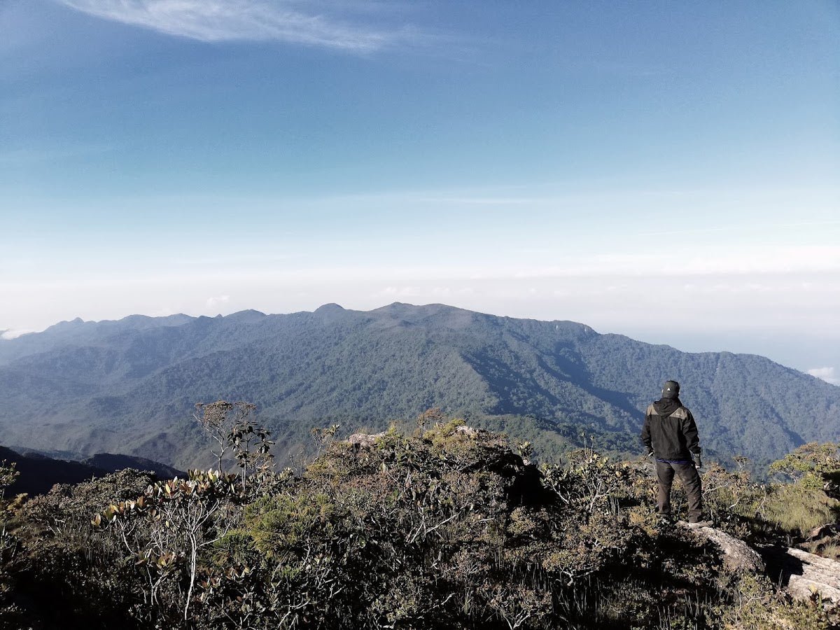
The summit rewards. On a clear day you get a panoramic view of Pahang rainforest, Gunung Jebak Puyuh, the Krau Wildlife Reserve, and the Pahang River stretching out below. It's a proper wilderness view — no pylons, no sprawl, just forest. AllTrails reviewers have given this trail 4.8 stars from 41 reviews, and the summit is a big part of why.

Caves at the Base Area
The summit trail is one part of Gunung Senyum. The cave complex at the base is the other, and it's worth your full attention. Depending on source, there are between 18 and 25-plus caves in the limestone karst, with somewhere between 11 and 20-plus accessible to the public. The highlights include Gua Angin (the Wind Cave — genuinely breezy inside), Gua Terang Bulan (a skylight throws rainbow light into the chamber), Gua Rangkak (a crawl-through cave with Quranic inscriptions on the walls), Gua Tapa (a meditation cave with a stone statue and three wells reportedly never running dry), and Gua Gajah (an elephant-shaped entrance). These are the kinds of caves that make this place unusual — it's not just a mountain hike, it's a geological and cultural experience at the base level.

Descent & Safety
Descending the upper boulder zone demands full concentration. Tired legs on wet limestone is how accidents happen. Take your time, test every handhold and foothold before committing weight to it, and do not glissade or rush on any rock surface. If it has rained, or if rain starts while you're up there, treat every surface as potentially slippery until you're back below CP3.
Many hikers descend via the East Trail (Timur) after ascending West — it's less technical and easier on tired knees. That said, "less technical" on Gunung Senyum is relative. It's still a challenging descent.
Key hazards to keep in mind throughout:
- Exposed rock and steep boulder sections — serious fall risk, confirmed by multiple sources. Dangerous in wet conditions.
- Fear of heights — explicitly flagged by AllTrails reviewers. Assess your group honestly before the upper section.
- No trail markers above CP3 — getting lost in this zone is a real risk without a guide (flagged by a May 2025 trip report).
- Slippery conditions when wet — rain transforms this trail. If weather turns, descend immediately.
- Unlighted caves — headlamp and helmet are essential for any cave exploration, not optional.
- No confirmed water sources on trail — carry everything you need from the car park.
- Leeches — not explicitly confirmed for this trail but you're in lowland tropical rainforest. Assume they're present and prepare accordingly.
Emergency contacts (all approximately 20 km from site):
- Hospital Jengka: 09-4662 333
- Balai Polis Jengka: 09-4662 452
- Balai Bomba Jengka: 09-4664 359
If you want a guide for the summit trail, Khairuddin (019-977 9618) from MGP Temerloh is confirmed by multiple Wikiloc reports. Hiring a local guide on a route with no markers above CP3 is not a luxury — it's a sensible safety decision.
What to Bring
The technical nature of this trail changes the gear calculus. Here's what matters for Gunung Senyum specifically:
- Water — carry at least 2–3 litres per person. No confirmed water sources on trail. The wells at Gua Tapa are reported perennial but potability is unconfirmed — don't rely on them. A TAHAN TrailBladder 2L Water Bladder keeps your hands free for scrambling, which matters a lot on this route.
- Headlamp — mandatory. The cave passages are unlighted. Bring spare batteries.
- Helmet — for cave sections specifically. Lowering your head fast in a semi-wild cave without a helmet is a bad idea.
- Hiking stick — useful on the forested lower sections and on descent. For the upper boulder zone you'll want both hands free, so collapsible is the only sensible option. The TAHAN 3-Section Foldable Hiking Stick V2 packs down small enough to stow when you hit the scrambling sections — that's the kind of practicality this trail demands.
- Grippy trail shoes or hiking boots — nothing smooth-soled on limestone. Wet rubber on wet karst is a fall waiting to happen.
- Gloves — thin grippy gloves for the boulder sections protect your hands and improve grip on rough rock.
- Rain layer — Pahang weather can turn fast. If rain comes in, you want to be able to move quickly, so a packable waterproof jacket is worth the space.
- Food and snacks — 3.5 to 6.5 hours is a wide range depending on cave exploration. Bring enough for the longer end.
- First aid kit — cuts and scrapes from rock scrambling are par for the course.
- Leech socks or leech spray — lowland rainforest, assume leeches.
- Charged phone, emergency contacts saved — Hospital Jengka 09-4662 333, guide Khairuddin 019-977 9618.
For a broader breakdown of what's worth spending on versus what you can skip, our hiking gear guide covers the essentials without the sales pitch.
FAQ
How hard is Gunung Senyum?
Hard — and that's the official AllTrails rating, not just trail talk. The upper section is described by one source as "80% rock climbing, 20% hiking." You're scrambling exposed boulders with no trail markers above the third checkpoint. This is not a beginner hike. You need to be physically fit, comfortable with heights, and ideally have some scrambling experience. In wet conditions it's a serious technical challenge. Come prepared or don't come for the summit.
How long does Gunung Senyum take?
Budget 3.5 to 6.5 hours for the round trip. AllTrails estimates 3.5–4 hours for the hiking component; the official park signboard states 6.5 hours, which likely reflects a proper cave exploration circuit as well. If you're doing summit plus caves, plan for the longer end. Start early — you want to be off the exposed upper section before afternoon weather builds.
Do I need a permit for Gunung Senyum?
Yes — it's a forest reserve managed by JPSM and you need a Permit Memasuki HSK. Call the Pegawai Hutan Daerah Temerloh/Bera at 09-2962 755 before your visit to confirm current permit requirements and any fees. Historical reports suggest entry has been free or low cost, but that may be outdated information. Don't show up without checking first.
Do I need a guide for Gunung Senyum?
No compulsory guide requirement is in place as far as current sources confirm. But above CP3 there are no trail markers, and a May 2025 report specifically called this out as a navigation hazard. Getting lost on exposed karst in lowland Pahang is not a situation you want to improvise your way out of. Khairuddin from MGP Temerloh (019-977 9618) is a known guide for this route. Hire one if it's your first time here, or if any member of your group is inexperienced on technical terrain.
Camp Nearby?
Making a weekend of it? Gunung Senyum is a solid day hike from Temerloh, but the drive from KL means an early start if you're not staying close. For camping options in the broader Pahang region worth considering the night before — or for a post-hike recovery camp — check out our reviews of Woodstock Camp Janda Baik, Glamping Valley @ Janda Baik, and Camp Mantap, Bentong. Janda Baik and Bentong sit in the Pahang foothills and put you closer to the mountain than driving from KL on the day itself — easier on the legs and a lot easier on the alarm clock.
Trail conditions, permit updates, and hiking buddies for the weekend — all in one WhatsApp group. Just ask; someone was probably up there last week.
💬 Join the Hiking CommunityFree, one click. No spam — the occasional promo at most.
Gear tip: Water bladder or bottle on a humid trail.
Mike has been camping across Malaysia for over 10 years — from jungle treks in Taman Negara to beach camps in Perhentian. He writes about it so you don't have to find out the hard way. Follow along on TAHAN Outdoor's blog for honest campsite reviews, every week.